That's a shame, because geography taught well builds global awareness, sharpens critical thinking, and grows genuine empathy for people who live differently than we do. It connects history, science, and culture into one map instead of teaching them as separate subjects.
This guide covers why so many geography lessons fall flat, the core concepts worth teaching, methods backed by learning science, and age-by-age strategies for parents and educators building a curriculum from scratch.
Key Takeaways
- Geography sticks best when tied to real people, places, and current events, not flashcards alone
- Pairing visual tools like maps and globes with spaced practice builds recall that lasts years, not days
- Games, apps, and hands-on projects keep reluctant learners curious at every grade level
- Classic geography themes give any lesson plan structure without making it feel like a worksheet
Why Traditional Geography Teaching Often Falls Short
Most geography classes follow a predictable rhythm: label a map, quiz on Friday, move to the next unit. Students memorize country shapes and capital cities for a test, then lose most of it within weeks.
The data backs this up. On the 2018 National Assessment of Educational Progress, only 25% of eighth-graders scored at or above "proficient" in geography, and 29% scored below "basic," according to the NAEP 2018 geography assessment. Average scores dropped compared to 2014. That leaves many students without a working mental map of the world.
A few recurring issues explain why:
- Isolated instruction: geography taught in a vacuum, disconnected from history, current events, or culture
- Passive review: reading a textbook chapter once, then testing, with no spaced practice
- No emotional hook: places reduced to shapes and labels rather than homes to real people
Some newer school models have rebuilt their approach to close this gap. The School House's American Emergent Curriculum, for instance, weaves geography into history, civics, and cultural studies rather than teaching it as an isolated block. That structure responds directly to the fragmented instruction that leaves students unable to place a country on a map years later.
The Building Blocks: Core Concepts Every Geography Lesson Should Cover
Spatial Thinking Comes First
Spatial thinking is the mental skill of understanding where things are and how they relate to each other. The National Research Council describes it as a blend of three elements: concepts of space, tools like maps to represent that space, and reasoning processes to interpret it all (National Research Council, Learning to Think Spatially).
In practice, kids need more than naming places. They need to picture how a river shapes where a city grew, or how a mountain range isolated a culture for centuries.
Three Branches, One Full Picture
- Physical geography: landforms, climate, water systems, natural resources
- Human geography: population, migration, culture, political boundaries
- Environmental geography: how people and environments shape each other
Teaching only one branch leaves gaps. A lesson on the Amazon rainforest that skips the Indigenous communities living there tells half a story.
Structuring a Lesson: A Practical Framework
Many teachers organize a geography lesson around a simple Who, What, When, Where, Why structure. Applied to a country study, it might look like this:
- Who lives there, and what do their daily lives look like?
- What natural resources or landmarks define the region?
- When did major historical or political shifts happen?
- Where does it sit relative to its neighbors and trade routes?
- Why does its location matter economically, culturally, or politically?
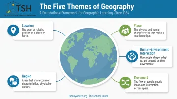
For a more established framework, geography education has long relied on five classic themes developed by educators in 1984:
- Location
- Place
- Human-environment interaction
- Movement
- Region
Current national geography standards group similar ideas into six broader "essential elements." The original five still show up in classrooms because they're simple to teach and easy to remember.
None of these frameworks matter much in isolation. They work when tied to an actual country, a real news story, or a book character's journey, not taught as an abstract checklist.
Proven Methods to Teach Geography Effectively
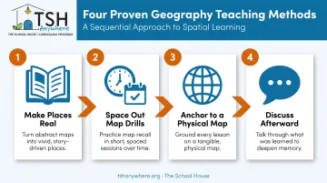
Make Places Real Before You Make Them Abstract
Kids remember a country better once they've "met" a family who lives there. Living geography swaps dry textbook descriptions for narrative-driven books and real photographs of daily life: a kid your child's age doing homework in Nairobi, riding a bus in Seoul.
This doesn't replace map work. It gives map work a reason to exist.
Drill the Map, But Space It Out
Repeating country names over and over in one sitting feels productive, but it isn't.
In a pair of 2006 experiments, students who took a practice test retained significantly more after two days and one week than students who only reread the same material—even though the rereading group felt more confident (Roediger and Karpicke, Psychological Science).
Applied to geography, that means:
- Quiz country locations in short, low-stakes bursts, not one long cram session
- Space repeat quizzes days or weeks apart, not back-to-back
- Mix older countries into new quizzes so nothing gets forgotten
This is the logic behind "map drilling" methods some homeschool programs use. Brief, repeated recall beats one long study block every time.
Anchor Everything to a Physical Map
Every book, news story, or history lesson gets stronger when a learner can point to it on a globe. Reading about ancient Egypt? Find the Nile. Following a news story about flooding in Pakistan? Locate it, trace the rivers, talk about elevation.
History and geography reinforce each other naturally this way. Mapping a historical empire's borders deepens both subjects at once, instead of treating them as separate units to check off.
Talk About It Afterward
Discussion after a lesson does more than a quiz alone. Ask why a city sits on a river, how climate shapes daily life, or what surprised them about a place. Explaining out loud turns locations into ideas kids can reuse.
The strongest geography instruction blends structure—frameworks, drills, spaced recall—with meaning through stories, culture, and real connection. The School House builds its geography strand the same way: pin-map work and cultural exploration paired with project-based dialogue, so kids explain what they learned instead of tapping a map and moving on.
Fun Activities and Tools to Bring Geography to Life
Geography sticks when kids do something with it. Fold a few of the ideas below into a normal week and place names stop feeling like flashcard fodder.
Hands-on activities
- Geography scavenger hunts: match objects or photos to clues about specific countries
- Puzzle maps: jigsaw pieces that build spatial memory through repetition
- Draw-your-own-island: invent a map with a legend, compass rose, and symbols
- Map bingo: call out capitals or landmarks and mark them on a personal map
- Pin maps: mark studied cities and regions on a shared wall or table map
Technology-based tools
- Location-guessing apps that play like a digital “name that country”
- Virtual field trips via street-view tools or museum sites
- Google Earth or online atlases for zooming from globe to street level
Cultural immersion
- Cook a dish from the region, then talk about why those ingredients grow there
- Play regional music or study traditional art while tracing its origins on a map
- Celebrate a local holiday or write a “postcard” from a city you’ve just studied
None of these need to be elaborate. A Saturday morning spent cooking a dish while listening to a podcast about the region teaches more geography than a month of quizzes ever could.
Adapting Geography Lessons by Age and Grade Level
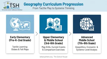
Early Elementary: Build the Foundation
Young learners need concrete, tactile experiences before abstract map-reading. Start with materials they can hold, move, and walk through:
- Floor-grid path maps kids can physically follow
- Globes to spin and compare land vs. water
- Picture books that introduce far-off places through story
- Felt or puzzle maps so continents and countries are placed by hand
At the earliest level, The School House uses felt continent maps this way—geography is learned through touch before it is learned through reading.
Upper Elementary & Middle School: Add Structure
Once the tactile base is in place, upper elementary and middle school students can handle drills, current events, and tighter frameworks.
Focus practice on:
- Map drills that build fluency with scale, legend, and direction
- Who-What-When-Where-Why breakdowns of places in the news
- Side-by-side comparison of different map types
- Simple reads of satellite images tied to a real question
By grade 8, national geography standards expect students to use maps to answer geographic questions—not only label them.
High School: Go Deeper
Older students can work at a systems level—geopolitics, economics, and human-environment interaction.
Strong prompts include:
- Why water scarcity drives migration in a specific region
- How physical geography shapes a country’s trade policy
- How a local land-use fight connects to a global pattern
By grade 12, standards expect students to evaluate data sources critically and defend those connections with evidence.
Frequently Asked Questions
What is the best way to teach geography?
Combine living, contextual learning, real stories, maps, and current events, with regular low-stakes practice like map drills. Structure without meaning gets forgotten; meaning without structure gets vague.
What are the 5 W's in geography?
Many teachers use Who, What, When, Where, and Why as a simple lesson structure: who lives there, what defines the place, when key events happened, where it sits relative to neighbors, and why that location matters.
What are the 7 key points of geography?
There's no single official "seven-point" list. Geography educators have long taught five core themes: location, place, human-environment interaction, movement, and region. Current national standards group similar ideas into six broader essential elements.
At what age should children start learning geography?
Basic concepts like maps, globes, and directions can start as early as preschool through simple, tactile activities. Complexity builds steadily through each grade, reaching geopolitical analysis by high school.
How can I make geography engaging for reluctant learners?
Lean on games, storytelling, and real-world hooks like food, music, or travel. A kid who won't memorize capitals might light up cooking a dish from the country they're studying.
What tools do I need to teach geography at home or in the classroom?
At minimum, a world map or globe and a few living books with real stories set in other places. Digital tools like geography apps or pin maps add practice without much extra cost.